9.37.1. Brief introduction 
In-application purchases are used by the application to purchase additional content or upgrade features.
9.37.2. Instance step 
1.在 iTunes 连接中请确保拥有一个唯一的 App ID(unique App ID ),当创建捆绑的ID( bundle ID)应用程序更新时,代码会以相应的配置文件签名在Xcode上
two。 Create new applications and update application information. You can learn more about it in Apple’s add new application documentation.
3.在应用程序页的管理应用程序( Manage In-App Purchase)中,为app内付费添加新产品
4.确保设置的应用程序为的银行详细。需要将其设置为在应用程序内购买(In-App purchase)。此外在 iTunes 中使用管理用户(Manage Users)选项,创建一个测试用户帐户连接您的应用程序的页。
5.下一步是与处理代码和为我们在应用程序内购买创建有关的 UI。
6.创建一个单一的视图应用程序,并在 iTunes 中指定的标识符连接输入捆绑标识符
7.更新ViewController.xib ,如下所示
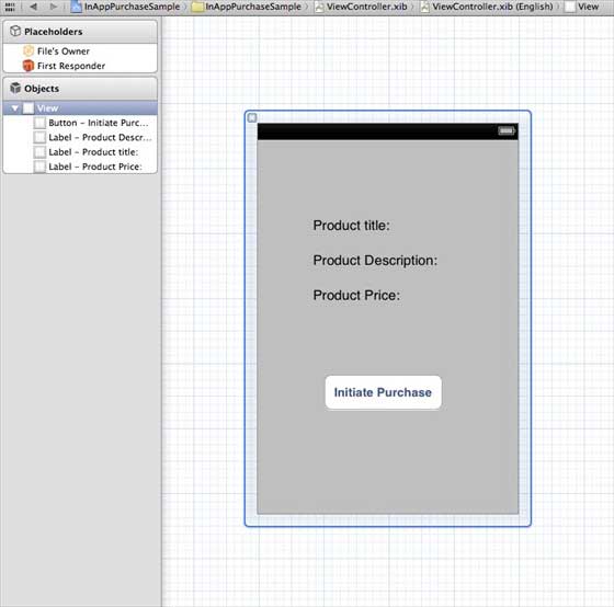
8.为三个标签创建IBOutlets,且将按钮分别命名为 productTitleLabel、 productDescriptionLabel、 productPriceLabel 和 purchaseButton
9.选择项目文件,然后选择目标,然后添加StoreKit.framework
10.更新ViewController.h ,如下所示
#import
#import
@interface ViewController : UIViewController<
SKProductsRequestDelegate,SKPaymentTransactionObserver>
{
SKProductsRequest *productsRequest;
NSArray *validProducts;
UIActivityIndicatorView *activityIndicatorView;
IBOutlet UILabel *productTitleLabel;
IBOutlet UILabel *productDescriptionLabel;
IBOutlet UILabel *productPriceLabel;
IBOutlet UIButton *purchaseButton;
}
- (void)fetchAvailableProducts;
- (BOOL)canMakePurchases;
- (void)purchaseMyProduct:(SKProduct*)product;
- (IBAction)purchase:(id)sender;
@end
11.更新ViewController.m ,如下所示
#import "ViewController.h"
#define kTutorialPointProductID
@"com.tutorialPoints.testApp.testProduct"
@interface ViewController ()
@end
@implementation ViewController
- (void)viewDidLoad
{
[super viewDidLoad];
// Adding activity indicator
activityIndicatorView = [[UIActivityIndicatorView alloc]
initWithActivityIndicatorStyle:UIActivityIndicatorViewStyleWhiteLarge];
activityIndicatorView.center = self.view.center;
[activityIndicatorView hidesWhenStopped];
[self.view addSubview:activityIndicatorView];
[activityIndicatorView startAnimating];
//Hide purchase button initially
purchaseButton.hidden = YES;
[self fetchAvailableProducts];
}
- (void)didReceiveMemoryWarning
{
[super didReceiveMemoryWarning];
// Dispose of any resources that can be recreated.
}
-(void)fetchAvailableProducts{
NSSet *productIdentifiers = [NSSet
setWithObjects:kTutorialPointProductID,nil];
productsRequest = [[SKProductsRequest alloc]
initWithProductIdentifiers:productIdentifiers];
productsRequest.delegate = self;
[productsRequest start];
}
- (BOOL)canMakePurchases
{
return [SKPaymentQueue canMakePayments];
}
- (void)purchaseMyProduct:(SKProduct*)product{
if ([self canMakePurchases]) {
SKPayment *payment = [SKPayment paymentWithProduct:product];
[[SKPaymentQueue defaultQueue] addTransactionObserver:self];
[[SKPaymentQueue defaultQueue] addPayment:payment];
}
else{
UIAlertView *alertView = [[UIAlertView alloc]initWithTitle:
@"Purchases are disabled in your device" message:nil delegate:
self cancelButtonTitle:@"Ok" otherButtonTitles: nil];
[alertView show];
}
}
-(IBAction)purchase:(id)sender{
[self purchaseMyProduct:[validProducts objectAtIndex:0]];
purchaseButton.enabled = NO;
}
#pragma mark StoreKit Delegate
-(void)paymentQueue:(SKPaymentQueue *)queue
updatedTransactions:(NSArray *)transactions {
for (SKPaymentTransaction *transaction in transactions) {
switch (transaction.transactionState) {
case SKPaymentTransactionStatePurchasing:
NSLog(@"Purchasing");
break;
case SKPaymentTransactionStatePurchased:
if ([transaction.payment.productIdentifier
isEqualToString:kTutorialPointProductID]) {
NSLog(@"Purchased ");
UIAlertView *alertView = [[UIAlertView alloc]initWithTitle:
@"Purchase is completed succesfully" message:nil delegate:
self cancelButtonTitle:@"Ok" otherButtonTitles: nil];
[alertView show];
}
[[SKPaymentQueue defaultQueue] finishTransaction:transaction];
break;
case SKPaymentTransactionStateRestored:
NSLog(@"Restored ");
[[SKPaymentQueue defaultQueue] finishTransaction:transaction];
break;
case SKPaymentTransactionStateFailed:
NSLog(@"Purchase failed ");
break;
default:
break;
}
}
}
-(void)productsRequest:(SKProductsRequest *)request
didReceiveResponse:(SKProductsResponse *)response
{
SKProduct *validProduct = nil;
int count = [response.products count];
if (count>0) {
validProducts = response.products;
validProduct = [response.products objectAtIndex:0];
if ([validProduct.productIdentifier
isEqualToString:kTutorialPointProductID]) {
[productTitleLabel setText:[NSString stringWithFormat:
@"Product Title: %@",validProduct.localizedTitle]];
[productDescriptionLabel setText:[NSString stringWithFormat:
@"Product Desc: %@",validProduct.localizedDescription]];
[productPriceLabel setText:[NSString stringWithFormat:
@"Product Price: %@",validProduct.price]];
}
} else {
UIAlertView *tmp = [[UIAlertView alloc]
initWithTitle:@"Not Available"
message:@"No products to purchase"
delegate:self
cancelButtonTitle:nil
otherButtonTitles:@"Ok", nil];
[tmp show];
}
[activityIndicatorView stopAnimating];
purchaseButton.hidden = NO;
}
@end
注意: You need to modify the kTutorialPointProductID in which you created In-App Pur (purchased in app). You can add multiple products by modifying the NSSet of the fetchAvailableProducts product identifier.
9.37.3. Output 
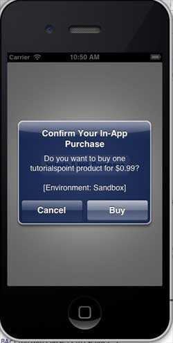
Run the application, and the output is as follows
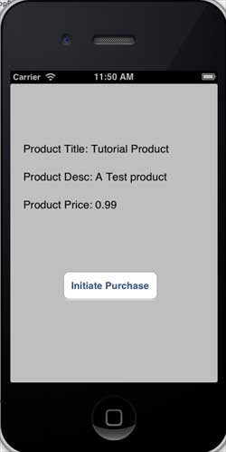
Make sure you are logged in. Click Buy to select an existing Apple ID. Enter a valid user name and password for the test account. After a few seconds, the following information is displayed
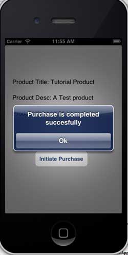
Once the product is purchased successfully, the following information will be obtained. You can update the code related to the application function where this information is displayed
-
1. Geographical Information Systems in the World Wide Web Era
4
-
2. Basic technology of WebGIS
4
-
3. Geographic Web Services
5
-
4. aggregation of geographical information
4
-
5. mobile GIS
5
-
6. Geographic information portal
3
-
7. New generation national spatial data infrastructure and GIS
4
-
8. Application of WebGIS in E-Commerce
3
-
9. Application of WebGIS in E-government
3
-
10. Hotspots and frontiers of WebGIS
2
-
1. Angularjs2
8
-
1. SVG tutorial
19
-
1. Memcached
20
-
1. C# tutorial
61
-
1. Sqlite
47
-
2. Go
43
-
2. Docker
59
-
2. Vue3
19
-
2. Servlet
21
-
3. React
23
-
3. SOAP tutorial
10
-
3. Android
18
-
3. Mongodb
44
-
3. Kotlin
18
-
4. Lua
31
-
4. MySQL tutorial
34
-
4. Appml
12
-
5. Perl
45
-
5. Postgresql
41
-
web
15
-
5. Web Services tutorial
6
-
6. Ruby
41
-
6. Design-pattern
35
-
7. Django
18
-
7. Rust
22
-
6. WSDL tutorial
8
-
8. Foundation
39
-
9. Ios
43
-
8. Css3
26
-
9. Swift
43
-
11. HTML tutorial-(HTML5 Standard)
54
-
12. Http
6
-
13. Regex
6
-
14. Regexp
7
Principles, Technologies, and Methods of Geographic Information Systems
102
In recent years, Geographic Information Systems (GIS) have undergone rapid development in both theoretical and practical dimensions. GIS has been widely applied for modeling and decision-making support across various fields such as urban management, regional planning, and environmental remediation, establishing geographic information as a vital component of the information era. The introduction of the “Digital Earth” concept has further accelerated the advancement of GIS, which serves as its technical foundation. Concurrently, scholars have been dedicated to theoretical research in areas like spatial cognition, spatial data uncertainty, and the formalization of spatial relationships. This reflects the dual nature of GIS as both an applied technology and an academic discipline, with the two aspects forming a mutually reinforcing cycle of progress.
-
1. Introduction to Geographic Information Systems
6
-
2. From the Real World to the Bit World
3
-
3. Spatial Data Model
7
-
4. Spatial Reference Systems and Map Projections
5
-
5. Data in GIS
4
-
6. Spatial data acquisition
2
-
7. Spatial Data Management
6
-
8. Spatial analysis
8
-
9. Digital Terrain Model (DTM) and Terrain Analysis
5
-
10. Spatial modeling and spatial decision support
6
-
11. Spatial data representation and map making
6
-
12. 3S Integration Technology
5
-
13. Network Geographic Information System
4
-
14. Examples of Geographic Information System Application
8
-
15. Organization and Management of Geographic Information System Application Projects
10
-
16. Geographic Information system Software Engineering Technology
7
-
17. Geographic Information System Standards
3
-
18. Geographic Information System and Society
3
-
19. Earth Information Science and Digital Earth
4