The continue statement in the Go language is a bit like the break statement. But continue instead of jumping out of the loop, skip the current loop to execute the next loop statement.
In for loop, execute continue statement triggers for executionof incremental statements.
In multiple loops, you can use labels In variables The execution result of the above example is: The following example has multiple loops that demonstrate the difference between using tags and not using tags: The execution result of the above example is: label mark one’s mind continue cycle. 2.27.1. Grammar #
continue syntax format is as follows:continue;
continue statement flow chart is as follows: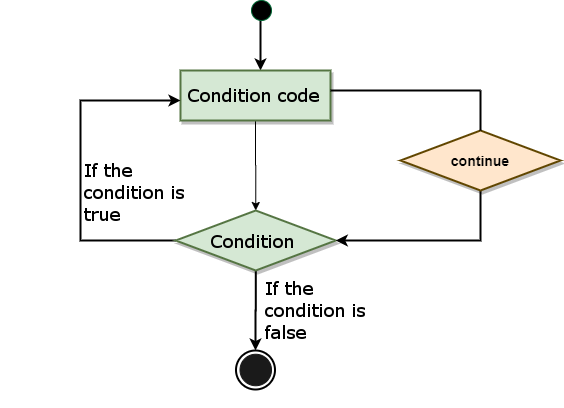
2.27.2. Example #
a equal to 15 skip this loop and execute the next loop:Example #
package main import "fmt" func main() { /* Define local variables */ var a int = 10 /* For loop */ for a < 20 { if a == 15 { /* Skip this loop */ a = a + 1; continue; } fmt.Printf("The value of a is: %d\\n", a); a++; } }
The value of a is: 10 The value of a is: 11 The value of a is: 12 The value of a is: 13 The value of a is: 14 The value of a is: 16 The value of a is: 17 The value of a is: 18 The value of a is: 19
Example #
package main import "fmt" func main() { // Do not use tags fmt.Println("---- continue ---- ") for i := 1; i <= 3; i++ { fmt.Printf("i: %d\\n", i) for i2 := 11; i2 <= 13; i2++ { fmt.Printf("i2: %d\\n", i2) continue } } // Using tags fmt.Println("---- continue label ----") re: for i := 1; i <= 3; i++ { fmt.Printf("i: %d\\n", i) for i2 := 11; i2 <= 13; i2++ { fmt.Printf("i2: %d\\n", i2) continue re } } }
---- continue ---- i: 1 i2: 11 i2: 12 i2: 13 i: 2 i2: 11 i2: 12 i2: 13 i: 3 i2: 11 i2: 12 i2: 13 ---- continue label ---- i: 1 i2: 11 i: 2 i2: 11 i: 3 i2: 11