In this section, we focus on how to create Maven project documents.
For example, we create a consumerBanking project under the C:/MVN directory, and Maven uses the following command to quickly create a java project:
mvn archetype:generate -DgroupId=com.companyname.bank -DartifactId=consumerBanking -DarchetypeArtifactId=maven-archetype-quickstart -DinteractiveMode=false
Modify the pom.xml to add the following configuration (if not available):
<project>...<build><pluginManagement><plugins><plugin><groupId>org.apache.maven.pluginsgroupId><artifactId>maven-site-pluginartifactId><version>3.3version>plugin><plugin><groupId>org.apache.maven.pluginsgroupId><artifactId>maven-project-info-reports-pluginartifactId><version>2.7version>plugin>plugins>pluginManagement>build>...project>
不然运行mvn site 命令时出现 **java.lang.NoClassDefFoundError:
org/apache/maven/doxia/siterenderer/DocumentContent** 的问题,
这是由于 maven-site-plugin 版本过低,升级到 3.3+ 即可。
Open the consumerBanking folder and execute the following mvn command.
C:\MVN\consumerBanking> mvn site
Maven begins to generate documentation:
[INFO] Scanning for projects...
[INFO] -------------------------------------------------------------------
[INFO] Building consumerBanking
[INFO]task-segment: [site]
[INFO] -------------------------------------------------------------------
[INFO] [site:site {execution: default-site}]
[INFO] artifact org.apache.maven.skins:maven-default-skin:
checking for updates from central
[INFO] Generating "About" report.
[INFO] Generating "Issue Tracking" report.
[INFO] Generating "Project Team" report.
[INFO] Generating "Dependencies" report.
[INFO] Generating "Continuous Integration" report.
[INFO] Generating "Source Repository" report.
[INFO] Generating "Project License" report.
[INFO] Generating "Mailing Lists" report.
[INFO] Generating "Plugin Management" report.
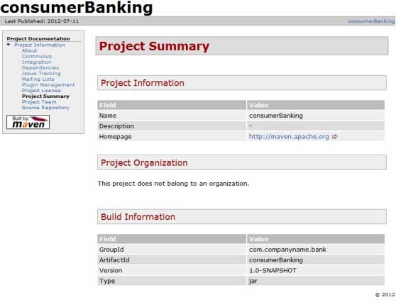
[INFO] Generating "Project Summary" report.
[INFO] -------------------------------------------------------------------
[INFO] BUILD SUCCESSFUL
[INFO] -------------------------------------------------------------------
[INFO] Total time: 16 seconds
[INFO] Finished at: Wed Jul 11 18:11:18 IST 2012
[INFO] Final Memory: 23M/148M
[INFO] -------------------------------------------------------------------
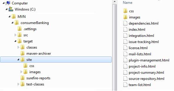
打开 C:MVNconsumerBankingtargetsite 文件夹。点击 index.html 就可以看到文档了。
Maven uses a file named Doxia Document processing engine to create documents, which can read various formats of source code into a common document model. To document your project, you can write the content in the following common formats that can be converted by Doxia.
Format name
Description
Referenc
Apt
Plain text document format
http://maven.apache.o rg/doxia/references/a pt-format.html
Xdoc
A document format for Maven 1.x
http://jakarta.apache .org/site/jakarta-sit e2.html
FML
FAQ documentation is applicable
http://maven.apache.o rg/doxia/references/f ml-format.html
XHTML
Extensible HTML documents
http://en.wikipedia.o rg/wiki/XHTML
-
1. Geographical Information Systems in the World Wide Web Era
4
-
2. Basic technology of WebGIS
4
-
3. Geographic Web Services
5
-
4. aggregation of geographical information
4
-
5. mobile GIS
5
-
6. Geographic information portal
3
-
7. New generation national spatial data infrastructure and GIS
4
-
8. Application of WebGIS in E-Commerce
3
-
9. Application of WebGIS in E-government
3
-
10. Hotspots and frontiers of WebGIS
2
-
1. Angularjs2
8
-
1. SVG tutorial
19
-
1. Memcached
20
-
1. C# tutorial
61
-
1. Sqlite
47
-
2. Go
43
-
2. Docker
59
-
2. Vue3
19
-
2. Servlet
21
-
3. React
23
-
3. SOAP tutorial
10
-
3. Android
18
-
3. Mongodb
44
-
3. Kotlin
18
-
4. Lua
31
-
4. MySQL tutorial
34
-
4. Appml
12
-
5. Perl
45
-
5. Postgresql
41
-
web
15
-
5. Web Services tutorial
6
-
6. Ruby
41
-
6. Design-pattern
35
-
7. Django
18
-
7. Rust
22
-
6. WSDL tutorial
8
-
8. Foundation
39
-
9. Ios
43
-
8. Css3
26
-
9. Swift
43
-
11. HTML tutorial-(HTML5 Standard)
54
-
12. Http
6
-
13. Regex
6
-
14. Regexp
7
Principles, Technologies, and Methods of Geographic Information Systems
102
In recent years, Geographic Information Systems (GIS) have undergone rapid development in both theoretical and practical dimensions. GIS has been widely applied for modeling and decision-making support across various fields such as urban management, regional planning, and environmental remediation, establishing geographic information as a vital component of the information era. The introduction of the “Digital Earth” concept has further accelerated the advancement of GIS, which serves as its technical foundation. Concurrently, scholars have been dedicated to theoretical research in areas like spatial cognition, spatial data uncertainty, and the formalization of spatial relationships. This reflects the dual nature of GIS as both an applied technology and an academic discipline, with the two aspects forming a mutually reinforcing cycle of progress.
-
1. Introduction to Geographic Information Systems
6
-
2. From the Real World to the Bit World
3
-
3. Spatial Data Model
7
-
4. Spatial Reference Systems and Map Projections
5
-
5. Data in GIS
4
-
6. Spatial data acquisition
2
-
7. Spatial Data Management
6
-
8. Spatial analysis
8
-
9. Digital Terrain Model (DTM) and Terrain Analysis
5
-
10. Spatial modeling and spatial decision support
6
-
11. Spatial data representation and map making
6
-
12. 3S Integration Technology
5
-
13. Network Geographic Information System
4
-
14. Examples of Geographic Information System Application
8
-
15. Organization and Management of Geographic Information System Application Projects
10
-
16. Geographic Information system Software Engineering Technology
7
-
17. Geographic Information System Standards
3
-
18. Geographic Information System and Society
3
-
19. Earth Information Science and Digital Earth
4