最近几年来,地理信息系统无论是在理论上还是应用上都处在一个飞速发展的阶段。 GIS被应用于多个领域的建模和决策支持,如城市管理、区划、环境整治等等,地理信息成为信息时代重要的组成部分之一; “数字地球”概念的提出,更进一步推动了作为其技术支撑的GIS的发展。 与此同时,一些学者致力于相关的理论研究,如空间感知、空间数据误差、空间关系的形式化等等。 这恰好说明了地理信息系统作为应用技术和学科的两个方面,并且这两个方面构成了相互促进的发展过程。
In this section, we focus on how to create Maven project documents.
For example, we create a consumerBanking project under the C:/MVN directory, and Maven uses the following command to quickly create a java project:
mvn archetype:generate -DgroupId=com.companyname.bank -DartifactId=consumerBanking -DarchetypeArtifactId=maven-archetype-quickstart -DinteractiveMode=false Modify the pom.xml to add the following configuration (if not available):
<project>...<build><pluginManagement><plugins><plugin><groupId>org.apache.maven.pluginsgroupId><artifactId>maven-site-pluginartifactId><version>3.3version>plugin><plugin><groupId>org.apache.maven.pluginsgroupId><artifactId>maven-project-info-reports-pluginartifactId><version>2.7version>plugin>plugins>pluginManagement>build>...project> 不然运行mvn site 命令时出现 **java.lang.NoClassDefFoundError: org/apache/maven/doxia/siterenderer/DocumentContent** 的问题, 这是由于 maven-site-plugin 版本过低,升级到 3.3+ 即可。
Open the consumerBanking folder and execute the following mvn command.
C:\MVN\consumerBanking> mvn site
Maven begins to generate documentation:
[INFO] Scanning for projects... [INFO] ------------------------------------------------------------------- [INFO] Building consumerBanking [INFO]task-segment: [site] [INFO] ------------------------------------------------------------------- [INFO] [site:site {execution: default-site}] [INFO] artifact org.apache.maven.skins:maven-default-skin: checking for updates from central [INFO] Generating "About" report. [INFO] Generating "Issue Tracking" report. [INFO] Generating "Project Team" report. [INFO] Generating "Dependencies" report. [INFO] Generating "Continuous Integration" report. [INFO] Generating "Source Repository" report. [INFO] Generating "Project License" report. [INFO] Generating "Mailing Lists" report. [INFO] Generating "Plugin Management" report. [INFO] Generating "Project Summary" report. [INFO] ------------------------------------------------------------------- [INFO] BUILD SUCCESSFUL [INFO] ------------------------------------------------------------------- [INFO] Total time: 16 seconds [INFO] Finished at: Wed Jul 11 18:11:18 IST 2012 [INFO] Final Memory: 23M/148M [INFO] -------------------------------------------------------------------
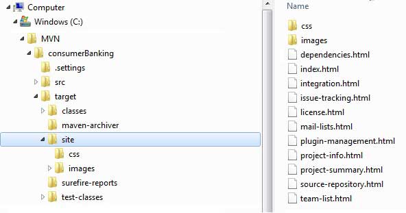
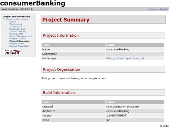
打开 C:MVNconsumerBankingtargetsite 文件夹。点击 index.html 就可以看到文档了。
Maven uses a file named Doxia Document processing engine to create documents, which can read various formats of source code into a common document model. To document your project, you can write the content in the following common formats that can be converted by Doxia.
Format name
Description
Referenc
Apt
Plain text document format
http://maven.apache.o rg/doxia/references/a pt-format.html
Xdoc
A document format for Maven 1.x
http://jakarta.apache .org/site/jakarta-sit e2.html
FML
FAQ documentation is applicable
http://maven.apache.o rg/doxia/references/f ml-format.html
XHTML
Extensible HTML documents
http://en.wikipedia.o rg/wiki/XHTML
-
1. Angularjs2
8
-
1. SVG tutorial
19
-
1. Memcached
20
-
1. C# tutorial
61
-
1. Sqlite
47
-
2. Go
43
-
2. Docker
59
-
2. Vue3
19
-
2. Servlet
21
-
3. React
23
-
3. SOAP tutorial
10
-
3. Android
18
-
3. Mongodb
44
-
3. Kotlin
18
-
4. Lua
31
-
4. MySQL tutorial
35
-
4. Appml
12
-
5. Perl
45
-
5. Postgresql
41
-
web
15
-
5. Web Services tutorial
6
-
6. Ruby
42
-
6. Design-pattern
35
-
7. Django
18
-
7. Rust
22
-
6. WSDL tutorial
8
-
8. Foundation
39
-
9. Ios
43
-
8. Css3
26
-
9. Swift
44
-
11. HTML tutorial-(HTML5 Standard)
54
-
12. Http
6
-
13. Regex
6
-
14. Regexp
8
-
1. Introduction to geographic information system
6
-
2. From the Real World to the Bit World
3
-
3. Spatial Data Model
7
-
4. 空间参照系统和 地图投影
5
-
5. Data in GIS
3
-
6. Spatial data acquisition
2
-
7. Spatial Data Management
6
-
8. Spatial analysis
8
-
9. 数字地形模型( DTM )与地形分析
5
-
10. 空间建模与 空间决策支持
6
-
11. Spatial data representation and map making
6
-
12. 3S Integration Technology
5
-
13. 网络地理信息系统
3
-
14. Examples of Geographic Information System Application
8
-
15. Organization and Management of Geographic Information System Application Projects
9
-
16. Geographic Information system Software Engineering Technology
6
-
17. Geographic Information System Standards
3
-
18. Geographic Information System and Society
3
-
19. Earth Information Science and Digital Earth
3
-
2. ADO tutorial
23
-
4. W3C tutorial
16
-
5. Data-structures
31
-
8. Scala
41
-
7. Bootstrap5
37
-
10. Markdown
10
-
9. Echarts
12
-
11. Maven
20
-
11.19. Maven NetBeans
-
11.9. Maven build & Project testing
-
11.17. Maven Web application
-
11.8. Maven builds Java project
-
11.11. Maven project template
-
11.18. Maven Eclipse
-
11.4. Maven build Lifecycle
-
11.6. Maven warehouse
-
11.5. Maven build profile
-
11.15. Maven dependency management
-
10. Font-awesome
17
-
12. RDF tutorial
11
-
13. Sass
15
-
15. XML Schema tutorial
56