Perl The syntax format is as follows: The following is Next, it will judge After the execution The conditions are judged again. If for Here, Execute the above program, and the output is as follows:
最近几年来,地理信息系统无论是在理论上还是应用上都处在一个飞速发展的阶段。 GIS被应用于多个领域的建模和决策支持,如城市管理、区划、环境整治等等,地理信息成为信息时代重要的组成部分之一; “数字地球”概念的提出,更进一步推动了作为其技术支撑的GIS的发展。 与此同时,一些学者致力于相关的理论研究,如空间感知、空间数据误差、空间关系的形式化等等。 这恰好说明了地理信息系统作为应用技术和学科的两个方面,并且这两个方面构成了相互促进的发展过程。 for loops are used to execute a sequence of statements multiple times, simplifying the code that manages loop variables. 5.21.1. Grammar #
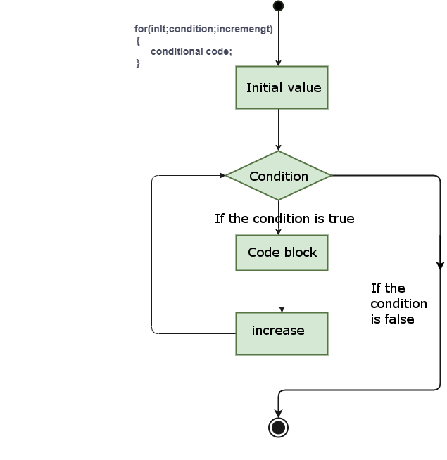
for ( init; condition; increment ){ statement(s); }
for analysis of the control flow of the loop: init will be executed first, and only once. This step allows you to declare and initialize any loop control variables. You can also not write any statements here, as long as a semicolon appears. condition . If for true loop body is executed if for false The loop body is not executed, and the control flow jumps to the following for next statement of the loop. for after looping the body, the control flow jumps back to the increment statement. This statement allows you to update loop control variables. This statement can be left blank as long as a semicolon appears after the condition. true loop is executed, and the process is repeated over and over again (loop body, then increase the step value, and then rejudge the condition) when the condition becomes false , for cycle ends. statement(s) can be a single statement or a block of code madeup of several statements. condition can be any expression when the condition is true the loopis executed when the condition is false , exit the loop. 5.21.2. Flow chart #
Example #
#!/usr/bin/perl# execute for circulatefor($a=0;$a<10 ;$a="$a+1){print"a's" < is:$a\\n";} pre value> The value of a is: 0 The value of a is: 1 The value of a is: 2 The value of a is: 3 The value of a is: 4 The value of a is: 5 The value of a is: 6 The value of a is: 7 The value of a is: 8 The value of a is: 9