Suppose object An invokes B to perform an operation, and once the operation is completed, object A must know that object B has completed the task and that object A will perform other necessary actions.
The key concepts in the above example are
An is the delegated object of B.
B refers to an A
A will implement B’s delegate method
B notify by entrusting method
Create a Delegates object
Create an application with a single view
Then select the file File-> New-> File…
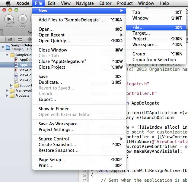
Then select Objective C and click next.
Name the subclass of SampleProtocol NSObject, as follows
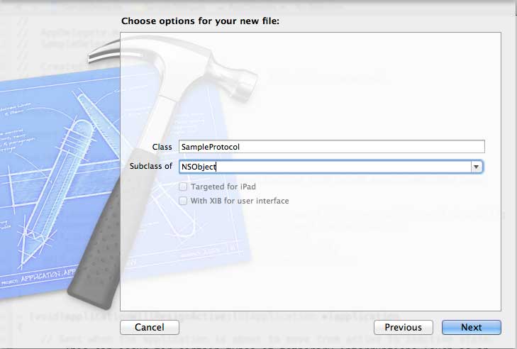
Then select create
6.向SampleProtocol.h文件夹中添加一种协议,然后更新代码,如下所示:
#import
// 协议定义
@protocol SampleProtocolDelegate
@required
- (void) processCompleted;
@end
// 协议定义结束
@interface SampleProtocol : NSObject
{
// Delegate to respond back
id _delegate;
}
@property (nonatomic,strong) id delegate;
-(void)startSampleProcess; // Instance method
@end
7.修改 SampleProtocol.m 文件代码,实现实例方法:
#import "SampleProtocol.h"
@implementation SampleProtocol
-(void)startSampleProcess{
[NSTimer scheduledTimerWithTimeInterval:3.0 target:self.delegate
selector:@selector(processCompleted) userInfo:nil repeats:NO];
}
@end
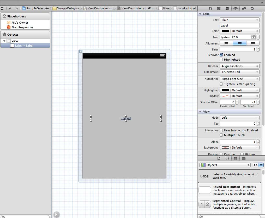
8. 将标签从对象库拖到UIView,从而在ViewController.xib中添加UILabel,如下所示:
9. 创建一个IBOutlet标签并命名为myLabel,然后按如下所示更新代码并在ViewController.h里显示SampleProtocolDelegate
#import
#import "SampleProtocol.h"
@interface ViewController : UIViewController<SampleProtocolDelegate>
{
IBOutlet UILabel *myLabel;
}
@end
10. 完成授权方法,为SampleProtocol创建对象和调用startSampleProcess方法。如下所示,更新ViewController.m文件
#import "ViewController.h"
@interface ViewController ()
@end
@implementation ViewController
- (void)viewDidLoad
{
[super viewDidLoad];
SampleProtocol *sampleProtocol = [[SampleProtocol alloc]init];
sampleProtocol.delegate = self;
[myLabel setText:@"Processing..."];
[sampleProtocol startSampleProcess];
// Do any additional setup after loading the view, typically from a nib.
}
- (void)didReceiveMemoryWarning
{
[super didReceiveMemoryWarning];
// Dispose of any resources that can be recreated.
}
#pragma mark - Sample protocol delegate
-(void)processCompleted{
[myLabel setText:@"Process Completed"];
}
@end
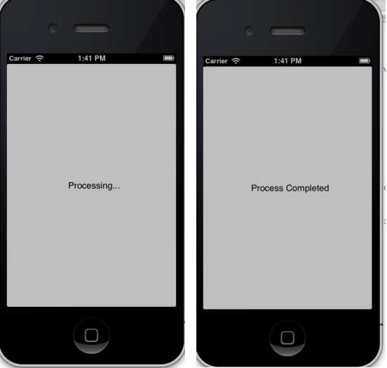
11. 将看到如下所示的输出结果,最初的标签也会继续运行,一旦授权方法被SampleProtocol对象所调用,标签运行程序的代码也会更新。
-
1. Geographical Information Systems in the World Wide Web Era
4
-
2. Basic technology of WebGIS
4
-
3. Geographic Web Services
5
-
4. aggregation of geographical information
4
-
5. mobile GIS
5
-
6. Geographic information portal
3
-
7. New generation national spatial data infrastructure and GIS
4
-
8. Application of WebGIS in E-Commerce
3
-
9. Application of WebGIS in E-government
3
-
10. Hotspots and frontiers of WebGIS
2
-
1. Angularjs2
8
-
1. SVG tutorial
19
-
1. Memcached
20
-
1. C# tutorial
61
-
1. Sqlite
47
-
2. Go
43
-
2. Docker
59
-
2. Vue3
19
-
2. Servlet
21
-
3. React
23
-
3. SOAP tutorial
10
-
3. Android
18
-
3. Mongodb
44
-
3. Kotlin
18
-
4. Lua
31
-
4. MySQL tutorial
34
-
4. Appml
12
-
5. Perl
45
-
5. Postgresql
41
-
web
15
-
5. Web Services tutorial
6
-
6. Ruby
41
-
6. Design-pattern
35
-
7. Django
18
-
7. Rust
22
-
6. WSDL tutorial
8
-
8. Foundation
39
-
9. Ios
43
-
8. Css3
26
-
9. Swift
43
-
11. HTML tutorial-(HTML5 Standard)
54
-
12. Http
6
-
13. Regex
6
-
14. Regexp
7
Principles, Technologies, and Methods of Geographic Information Systems
102
In recent years, Geographic Information Systems (GIS) have undergone rapid development in both theoretical and practical dimensions. GIS has been widely applied for modeling and decision-making support across various fields such as urban management, regional planning, and environmental remediation, establishing geographic information as a vital component of the information era. The introduction of the “Digital Earth” concept has further accelerated the advancement of GIS, which serves as its technical foundation. Concurrently, scholars have been dedicated to theoretical research in areas like spatial cognition, spatial data uncertainty, and the formalization of spatial relationships. This reflects the dual nature of GIS as both an applied technology and an academic discipline, with the two aspects forming a mutually reinforcing cycle of progress.
-
1. Introduction to Geographic Information Systems
6
-
2. From the Real World to the Bit World
3
-
3. Spatial Data Model
7
-
4. Spatial Reference Systems and Map Projections
5
-
5. Data in GIS
4
-
6. Spatial data acquisition
2
-
7. Spatial Data Management
6
-
8. Spatial analysis
8
-
9. Digital Terrain Model (DTM) and Terrain Analysis
5
-
10. Spatial modeling and spatial decision support
6
-
11. Spatial data representation and map making
6
-
12. 3S Integration Technology
5
-
13. Network Geographic Information System
4
-
14. Examples of Geographic Information System Application
8
-
15. Organization and Management of Geographic Information System Application Projects
10
-
16. Geographic Information system Software Engineering Technology
7
-
17. Geographic Information System Standards
3
-
18. Geographic Information System and Society
3
-
19. Earth Information Science and Digital Earth
4