最近几年来,地理信息系统无论是在理论上还是应用上都处在一个飞速发展的阶段。 GIS被应用于多个领域的建模和决策支持,如城市管理、区划、环境整治等等,地理信息成为信息时代重要的组成部分之一; “数字地球”概念的提出,更进一步推动了作为其技术支撑的GIS的发展。 与此同时,一些学者致力于相关的理论研究,如空间感知、空间数据误差、空间关系的形式化等等。 这恰好说明了地理信息系统作为应用技术和学科的两个方面,并且这两个方面构成了相互促进的发展过程。
Suppose object An invokes B to perform an operation, and once the operation is completed, object A must know that object B has completed the task and that object A will perform other necessary actions.
The key concepts in the above example are
An is the delegated object of B.
B refers to an A
A will implement B’s delegate method
B notify by entrusting method
Create a Delegates object
Create an application with a single view
Then select the file File-> New-> File…
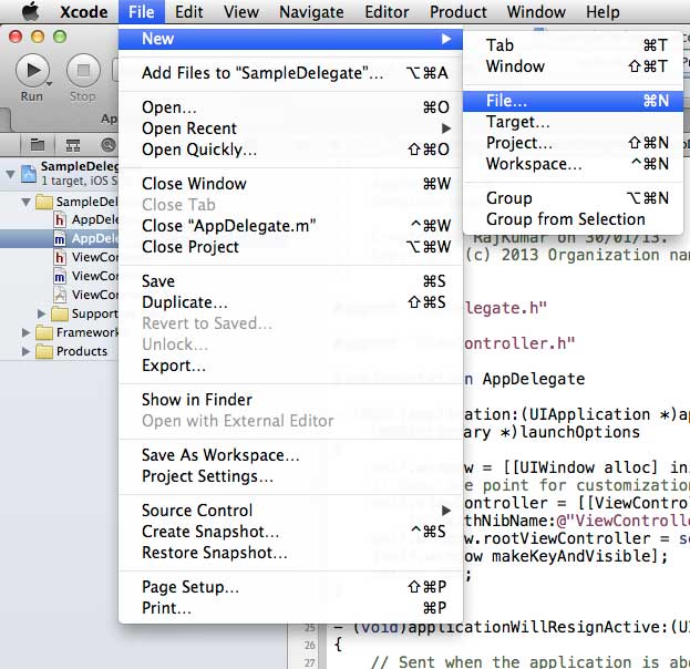
Then select Objective C and click next.
Name the subclass of SampleProtocol NSObject, as follows
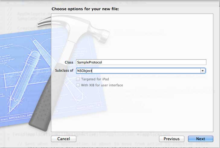
Then select create
6.向SampleProtocol.h文件夹中添加一种协议,然后更新代码,如下所示:
#import // 协议定义 @protocol SampleProtocolDelegate @required - (void) processCompleted; @end // 协议定义结束 @interface SampleProtocol : NSObject { // Delegate to respond back id _delegate; } @property (nonatomic,strong) id delegate; -(void)startSampleProcess; // Instance method @end 7.修改 SampleProtocol.m 文件代码,实现实例方法:
#import "SampleProtocol.h" @implementation SampleProtocol -(void)startSampleProcess{ [NSTimer scheduledTimerWithTimeInterval:3.0 target:self.delegate selector:@selector(processCompleted) userInfo:nil repeats:NO]; } @end
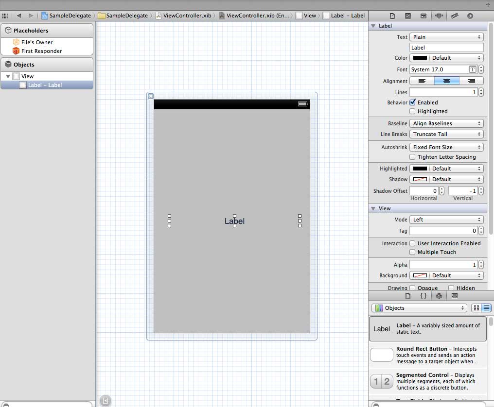
8. 将标签从对象库拖到UIView,从而在ViewController.xib中添加UILabel,如下所示:
9. 创建一个IBOutlet标签并命名为myLabel,然后按如下所示更新代码并在ViewController.h里显示SampleProtocolDelegate
#import #import "SampleProtocol.h" @interface ViewController : UIViewController<SampleProtocolDelegate> { IBOutlet UILabel *myLabel; } @end 10. 完成授权方法,为SampleProtocol创建对象和调用startSampleProcess方法。如下所示,更新ViewController.m文件
#import "ViewController.h" @interface ViewController () @end @implementation ViewController - (void)viewDidLoad { [super viewDidLoad]; SampleProtocol *sampleProtocol = [[SampleProtocol alloc]init]; sampleProtocol.delegate = self; [myLabel setText:@"Processing..."]; [sampleProtocol startSampleProcess]; // Do any additional setup after loading the view, typically from a nib. } - (void)didReceiveMemoryWarning { [super didReceiveMemoryWarning]; // Dispose of any resources that can be recreated. } #pragma mark - Sample protocol delegate -(void)processCompleted{ [myLabel setText:@"Process Completed"]; } @end
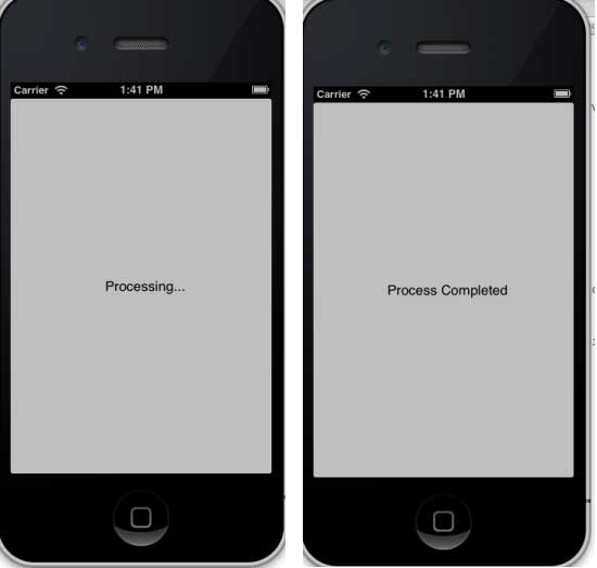
11. 将看到如下所示的输出结果,最初的标签也会继续运行,一旦授权方法被SampleProtocol对象所调用,标签运行程序的代码也会更新。
-
1. Angularjs2
8
-
1. SVG tutorial
19
-
1. Memcached
20
-
1. C# tutorial
61
-
1. Sqlite
47
-
2. Go
43
-
2. Docker
59
-
2. Vue3
19
-
2. Servlet
21
-
3. React
23
-
3. SOAP tutorial
10
-
3. Android
18
-
3. Mongodb
44
-
3. Kotlin
18
-
4. Lua
31
-
4. MySQL tutorial
35
-
4. Appml
12
-
5. Perl
45
-
5. Postgresql
41
-
web
15
-
5. Web Services tutorial
6
-
6. Ruby
42
-
6. Design-pattern
35
-
7. Django
18
-
7. Rust
22
-
6. WSDL tutorial
8
-
8. Foundation
39
-
9. Ios
43
-
9.22. The use of IOS View switching
-
9.5. Create the first iPhone application
-
9.19. Use of table view
-
9.33. IOS sends email
-
9.31. IOS positioning operation
-
9.28. IOS accelerometer (accelerometer)
-
>
9.7. Delegate (Delegates) example
-
9.37. In-app purchase of IOS
-
9.40. IOS storyboard (Storyboards)
-
9.10. Why use different input types?
-
8. Css3
26
-
9. Swift
44
-
11. HTML tutorial-(HTML5 Standard)
54
-
12. Http
6
-
13. Regex
6
-
14. Regexp
8
-
1. Introduction to geographic information system
6
-
2. From the Real World to the Bit World
3
-
3. Spatial Data Model
7
-
4. 空间参照系统和 地图投影
5
-
5. Data in GIS
3
-
6. Spatial data acquisition
2
-
7. Spatial Data Management
6
-
8. Spatial analysis
8
-
9. 数字地形模型( DTM )与地形分析
5
-
10. 空间建模与 空间决策支持
6
-
11. Spatial data representation and map making
6
-
12. 3S Integration Technology
5
-
13. 网络地理信息系统
3
-
14. Examples of Geographic Information System Application
8
-
15. Organization and Management of Geographic Information System Application Projects
9
-
16. Geographic Information system Software Engineering Technology
6
-
17. Geographic Information System Standards
3
-
18. Geographic Information System and Society
3
-
19. Earth Information Science and Digital Earth
3