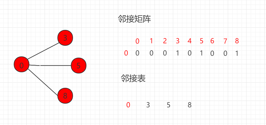
The most common operation in graph theory is to traverse adjacent edges, traversing related adjacent edges through a vertex. The time complexity of traversing the adjacent edges of the adjacency matrix is O (V), and the adjacency table can be found directly, which is more efficient.
邻接矩阵迭代:
...
public Iterable<Integer> adj(int v) {
    assert v >= 0 && v < n;
    Vector<Integer> adjV = new Vector<Integer>();
    for(int i = 0 ; i < n ; i ++ )
        if( g[v][i] )
            adjV.add(i);
    return adjV;
}
...
邻接表迭代:
...
// 返回图中一个顶点的所有邻边
// 由于java使用引用机制,返回一个Vector不会带来额外开销,
public Iterable adj(int v) {
assert v >= 0 && v < n;
return g[v];
}
...
For the expression of these two graphs, we can abstract an interface and generate the framework of this algorithm, regardless of whether the underlying layer is the adjacency table or the adjacency matrix.
This section writes a test case GraphReadTest, which can be viewed in the read package by calling the abstract interface implementation diagram.
/*\*
\* 图的抽象接口
*/
public interface Graph {
public int V();
public int E();
public void addEdge( int v , int w );
boolean hasEdge( int v , int w );
void show();
public Iterable<Integer> adj(int v);
}
5.29.1. Java instance code 
源码包下载: Download
(1)邻接矩阵迭代
Src/runoob/graph/DenseGraphIterater.java file code: 
package runoob.graph;
import java.util.Vector;
/*\*
\* 邻接矩阵迭代
*/
public class DenseGraphIterater {
// 节点数
private int n;
// 边数
private int m;
// 是否为有向图
private boolean directed;
// 图的具体数据
private boolean[][] g;
// 构造函数
public DenseGraphIterater( int n , boolean directed ){
assert n >= 0;
this.n = n;
this.m = 0;
this.directed = directed;
// g初始化为n*n的布尔矩阵, 每一个g[i][j]均为false,
表示没有任和边
// false为boolean型变量的默认值
g = new boolean[n][n];
}
// 返回节点个数
public int V(){ return n;}
// 返回边的个数
public int E(){ return m;}
// 向图中添加一个边
public void addEdge( int v , int w ){
assert v >= 0 && v < n ;
assert w >= 0 && w < n ;
if( hasEdge( v , w ) )
return;
g[v][w] = true;
if( !directed )
g[w][v] = true;
m ++;
}
// 验证图中是否有从v到w的边
boolean hasEdge( int v , int w ){
assert v >= 0 && v < n ;
assert w >= 0 && w < n ;
return g[v][w];
}
// 返回图中一个顶点的所有邻边
// 由于java使用引用机制,返回一个Vector不会带来额外开销,
public Iterable adj(int v) {
assert v >= 0 && v < n;
Vector adjV = new Vector();
for(int i = 0 ; i < n ; i ++ )
if( g[v][i] )
adjV.add(i);
return adjV;
}
}
(2)邻接表迭代
Src/runoob/graph/SparseGraphIterater.java file code: 
package runoob.graph;
import java.util.Vector;
/*\*
\* 邻接表迭代
*/
public class SparseGraphIterater {
private int n; // 节点数
private int m; // 边数
private boolean directed; // 是否为有向图
private Vector[] g; // 图的具体数据
// 构造函数
public SparseGraphIterater( int n , boolean directed ){
assert n >= 0;
this.n = n;
this.m = 0; // 初始化没有任何边
this.directed = directed;
// g初始化为n个空的vector, 表示每一个g[i]都为空, 即没有任和边
g = (Vector[])new Vector[n];
for(int i = 0 ; i < n ; i ++)
g[i] = new Vector();
}
public int V(){ return n;} // 返回节点个数
public int E(){ return m;} // 返回边的个数
// 向图中添加一个边
public void addEdge( int v, int w ){
assert v >= 0 && v < n ;
assert w >= 0 && w < n ;
g[v].add(w);
if( v != w && !directed )
g[w].add(v);
m ++;
}
// 验证图中是否有从v到w的边
boolean hasEdge( int v , int w ){
assert v >= 0 && v < n ;
assert w >= 0 && w < n ;
for( int i = 0 ; i < g[v].size() ; i ++ )
if( g[v].elementAt(i) == w )
return true;
return false;
}
// 返回图中一个顶点的所有邻边
// 由于java使用引用机制,返回一个Vector不会带来额外开销,
public Iterable adj(int v) {
assert v >= 0 && v < n;
return g[v];
}
}
-
1. Geographical Information Systems in the World Wide Web Era
4
-
2. Basic technology of WebGIS
4
-
3. Geographic Web Services
5
-
4. aggregation of geographical information
4
-
5. mobile GIS
5
-
6. Geographic information portal
3
-
7. New generation national spatial data infrastructure and GIS
4
-
8. Application of WebGIS in E-Commerce
3
-
9. Application of WebGIS in E-government
3
-
10. Hotspots and frontiers of WebGIS
2
-
1. Angularjs2
8
-
1. SVG tutorial
19
-
1. Memcached
20
-
1. C# tutorial
61
-
1. Sqlite
47
-
2. Go
43
-
2. Docker
59
-
2. Vue3
19
-
2. Servlet
21
-
3. React
23
-
3. SOAP tutorial
10
-
3. Android
18
-
3. Mongodb
44
-
3. Kotlin
18
-
4. Lua
31
-
4. MySQL tutorial
34
-
4. Appml
12
-
5. Perl
45
-
5. Postgresql
41
-
web
15
-
5. Web Services tutorial
6
-
6. Ruby
41
-
6. Design-pattern
35
-
7. Django
18
-
7. Rust
22
-
6. WSDL tutorial
8
-
8. Foundation
39
-
9. Ios
43
-
8. Css3
26
-
9. Swift
43
-
11. HTML tutorial-(HTML5 Standard)
54
-
12. Http
6
-
13. Regex
6
-
14. Regexp
7
Principles, Technologies, and Methods of Geographic Information Systems
102
In recent years, Geographic Information Systems (GIS) have undergone rapid development in both theoretical and practical dimensions. GIS has been widely applied for modeling and decision-making support across various fields such as urban management, regional planning, and environmental remediation, establishing geographic information as a vital component of the information era. The introduction of the “Digital Earth” concept has further accelerated the advancement of GIS, which serves as its technical foundation. Concurrently, scholars have been dedicated to theoretical research in areas like spatial cognition, spatial data uncertainty, and the formalization of spatial relationships. This reflects the dual nature of GIS as both an applied technology and an academic discipline, with the two aspects forming a mutually reinforcing cycle of progress.
-
1. Introduction to Geographic Information Systems
6
-
2. From the Real World to the Bit World
3
-
3. Spatial Data Model
7
-
4. Spatial Reference Systems and Map Projections
5
-
5. Data in GIS
4
-
6. Spatial data acquisition
2
-
7. Spatial Data Management
6
-
8. Spatial analysis
8
-
9. Digital Terrain Model (DTM) and Terrain Analysis
5
-
10. Spatial modeling and spatial decision support
6
-
11. Spatial data representation and map making
6
-
12. 3S Integration Technology
5
-
13. Network Geographic Information System
4
-
14. Examples of Geographic Information System Application
8
-
15. Organization and Management of Geographic Information System Application Projects
10
-
16. Geographic Information system Software Engineering Technology
7
-
17. Geographic Information System Standards
3
-
18. Geographic Information System and Society
3
-
19. Earth Information Science and Digital Earth
4