9.31.1. Brief introduction 
Through CoreLocation positioning in IOS, the current location of the user can be obtained, and the device movement information can be obtained at the same time.
9.31.2. Instance step 
1、创建一个简单的View based application(视图应用程序)。
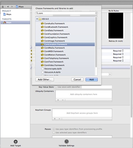
2、择项目文件,然后选择目标,然后添加CoreLocation.framework,如下所示
3、在ViewController.xib中添加两个标签,创建ibOutlet名为latitudeLabel和longtitudeLabel的标签
4、现在通过选择” File-> New -> File… -> “选择Objective C class 并单击下一步
5、把”sub class of”作为NSObject,将类命名为LocationHandler
6、选择创建
7、更新LocationHandler.h,如下所示
#import
#import
@protocol LocationHandlerDelegate <NSObject>
@required
-(void) didUpdateToLocation:(CLLocation*)newLocation
fromLocation:(CLLocation*)oldLocation;
@end
@interface LocationHandler : NSObject<CLLocationManagerDelegate>
{
CLLocationManager *locationManager;
}
@property(nonatomic,strong) id<LocationHandlerDelegate> delegate;
+(id)getSharedInstance;
-(void)startUpdating;
-(void) stopUpdating;
@end
8、更新LocationHandler.m,如下所示
#import "LocationHandler.h"
static LocationHandler *DefaultManager = nil;
@interface LocationHandler()
-(void)initiate;
@end
@implementation LocationHandler
+(id)getSharedInstance{
if (!DefaultManager) {
DefaultManager = [[self allocWithZone:NULL]init];
[DefaultManager initiate];
}
return DefaultManager;
}
-(void)initiate{
locationManager = [[CLLocationManager alloc]init];
locationManager.delegate = self;
}
-(void)startUpdating{
[locationManager startUpdatingLocation];
}
-(void) stopUpdating{
[locationManager stopUpdatingLocation];
}
-(void)locationManager:(CLLocationManager *)manager didUpdateToLocation:
(CLLocation *)newLocation fromLocation:(CLLocation *)oldLocation{
if ([self.delegate respondsToSelector:@selector
(didUpdateToLocation:fromLocation:)])
{
[self.delegate didUpdateToLocation:oldLocation
fromLocation:newLocation];
}
}
@end
9、更新ViewController.h,如下所示
#import
#import "LocationHandler.h"
@interface ViewController : UIViewController<LocationHandlerDelegate>
{
IBOutlet UILabel *latitudeLabel;
IBOutlet UILabel *longitudeLabel;
}
@end
10、更新ViewController.m,如下所示
#import "ViewController.h"
@interface ViewController ()
@end
@implementation ViewController
- (void)viewDidLoad
{
[super viewDidLoad];
[[LocationHandler getSharedInstance]setDelegate:self];
[[LocationHandler getSharedInstance]startUpdating];
}
- (void)didReceiveMemoryWarning
{
[super didReceiveMemoryWarning];
// Dispose of any resources that can be recreated.
}
-(void)didUpdateToLocation:(CLLocation *)newLocation
fromLocation:(CLLocation *)oldLocation{
[latitudeLabel setText:[NSString stringWithFormat:
@"Latitude: %f",newLocation.coordinate.latitude]];
[longitudeLabel setText:[NSString stringWithFormat:
@"Longitude: %f",newLocation.coordinate.longitude]];
}
@end
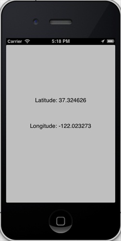
9.31.3. Output 
When we run the application, we get the following output:
-
1. Geographical Information Systems in the World Wide Web Era
4
-
2. Basic technology of WebGIS
4
-
3. Geographic Web Services
5
-
4. aggregation of geographical information
4
-
5. mobile GIS
5
-
6. Geographic information portal
3
-
7. New generation national spatial data infrastructure and GIS
4
-
8. Application of WebGIS in E-Commerce
3
-
9. Application of WebGIS in E-government
3
-
10. Hotspots and frontiers of WebGIS
2
-
1. Angularjs2
8
-
1. SVG tutorial
19
-
1. Memcached
20
-
1. C# tutorial
61
-
1. Sqlite
47
-
2. Go
43
-
2. Docker
59
-
2. Vue3
19
-
2. Servlet
21
-
3. React
23
-
3. SOAP tutorial
10
-
3. Android
18
-
3. Mongodb
44
-
3. Kotlin
18
-
4. Lua
31
-
4. MySQL tutorial
34
-
4. Appml
12
-
5. Perl
45
-
5. Postgresql
41
-
web
15
-
5. Web Services tutorial
6
-
6. Ruby
41
-
6. Design-pattern
35
-
7. Django
18
-
7. Rust
22
-
6. WSDL tutorial
8
-
8. Foundation
39
-
9. Ios
43
-
8. Css3
26
-
9. Swift
43
-
11. HTML tutorial-(HTML5 Standard)
54
-
12. Http
6
-
13. Regex
6
-
14. Regexp
7
Principles, Technologies, and Methods of Geographic Information Systems
102
In recent years, Geographic Information Systems (GIS) have undergone rapid development in both theoretical and practical dimensions. GIS has been widely applied for modeling and decision-making support across various fields such as urban management, regional planning, and environmental remediation, establishing geographic information as a vital component of the information era. The introduction of the “Digital Earth” concept has further accelerated the advancement of GIS, which serves as its technical foundation. Concurrently, scholars have been dedicated to theoretical research in areas like spatial cognition, spatial data uncertainty, and the formalization of spatial relationships. This reflects the dual nature of GIS as both an applied technology and an academic discipline, with the two aspects forming a mutually reinforcing cycle of progress.
-
1. Introduction to Geographic Information Systems
6
-
2. From the Real World to the Bit World
3
-
3. Spatial Data Model
7
-
4. Spatial Reference Systems and Map Projections
5
-
5. Data in GIS
4
-
6. Spatial data acquisition
2
-
7. Spatial Data Management
6
-
8. Spatial analysis
8
-
9. Digital Terrain Model (DTM) and Terrain Analysis
5
-
10. Spatial modeling and spatial decision support
6
-
11. Spatial data representation and map making
6
-
12. 3S Integration Technology
5
-
13. Network Geographic Information System
4
-
14. Examples of Geographic Information System Application
8
-
15. Organization and Management of Geographic Information System Application Projects
10
-
16. Geographic Information system Software Engineering Technology
7
-
17. Geographic Information System Standards
3
-
18. Geographic Information System and Society
3
-
19. Earth Information Science and Digital Earth
4