最近几年来,地理信息系统无论是在理论上还是应用上都处在一个飞速发展的阶段。 GIS被应用于多个领域的建模和决策支持,如城市管理、区划、环境整治等等,地理信息成为信息时代重要的组成部分之一; “数字地球”概念的提出,更进一步推动了作为其技术支撑的GIS的发展。 与此同时,一些学者致力于相关的理论研究,如空间感知、空间数据误差、空间关系的形式化等等。 这恰好说明了地理信息系统作为应用技术和学科的两个方面,并且这两个方面构成了相互促进的发展过程。
HTTP protocol is the abbreviation of Hyper Text Transfer Protocol (Hypertexttransfer Protocol). It is a transport protocol used to transfer hypertext from a WWW:World Wide Web server to a local browser.
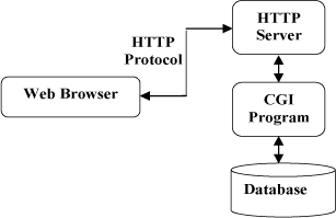
HTTP is a communication protocol based on TCP/IP to transfer data (HTML files, picture files, query results, etc.). The HTTP protocol works on the client-server architecture. As a HTTP client,the browser sends all requests to the HTTP server, the WEB server, through URL. Web servers include: Apache server, IIS server (Internet Information Services) and so on. After receiving the request, the Web server sends response information to the client. The default port number for HTTP is 80, but you can also change it to 8080 or another port. There are three points to note for HTTP: HTTP is connectionless: connectionless means limiting the processing of onlyone request per connection. After the server processes the customer’s request and receives the customer’s reply, it disconnects. Transmission timecan be saved in this way. HTTP is media independent: this means that any type of data can be sent overHTTP as long as the client and server know how to handle the data content. The client and server specify that the appropriate HTTP is stateless: the HTTP protocol is stateless. Statelessness means that the protocol has no memory ability for transactions. The lack of state meansthat if the previous information is required for subsequent processing, it must be retransmitted, which may result in an increase in the amount of datatransmitted per connection. On the other hand, the server responds faster when it does not need previous information. The following chart shows the HTTP protocol communication process: 12.2.1. How HTTP works 
MIME-type content type.