最近几年来,地理信息系统无论是在理论上还是应用上都处在一个飞速发展的阶段。 GIS被应用于多个领域的建模和决策支持,如城市管理、区划、环境整治等等,地理信息成为信息时代重要的组成部分之一; “数字地球”概念的提出,更进一步推动了作为其技术支撑的GIS的发展。 与此同时,一些学者致力于相关的理论研究,如空间感知、空间数据误差、空间关系的形式化等等。 这恰好说明了地理信息系统作为应用技术和学科的两个方面,并且这两个方面构成了相互促进的发展过程。
HTTP is a client / server-based architecture model that exchanges information through a reliable link and is a stateless request / response protocol.
An HTTP “client” is an application (Web browser or any other client) that connects to the server to send one or more HTTP requests to the server.
A HTTP “server” is also an application (usually a Web service, such as an Apache Web server or IIS server, etc.) by receiving requests from the clientand sending HTTP response data to the client.
HTTP uses uniform resource identifiers (Uniform Resource Identifiers, URI) to transfer data and establish connections.
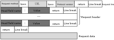
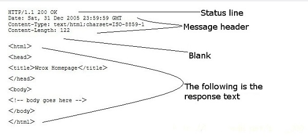
Once the connection is established, the data message is in a format similar to that used by Internet mail [RFC5322] And Multi-purpose Internet Mail extensions (MIME) [RFC2045] To transmit. The request message that the client sends a HTTP request to the server includes the following format: request line (request line), request header (header), blank line and request data. The following figure shows the general format of the request message. The HTTP response also consists of four parts: the status line, the message header, the blank line, and the response body. The following example is a typical use of Client request: Server response: Output result: 12.3.1. Client request message 
12.3.2. Server response message 
12.3.3. Example 
GET to pass an example of data:GET /hello.txt HTTP/1.1 User-Agent: curl/7.16.3 libcurl/7.16.3 OpenSSL/0.9.7l zlib/1.2.3 Host: www.example.com Accept-Language: en, mi
HTTP/1.1 200 OK Date: Mon, 27 Jul 2009 12:28:53 GMT Server: Apache Last-Modified: Wed, 22 Jul 2009 19:15:56 GMT ETag: "34aa387-d-1568eb00" Accept-Ranges: bytes Content-Length: 51 Vary: Accept-Encoding Content-Type: text/plain
Hello World! My payload includes a trailing CRLF.