最近几年来,地理信息系统无论是在理论上还是应用上都处在一个飞速发展的阶段。 GIS被应用于多个领域的建模和决策支持,如城市管理、区划、环境整治等等,地理信息成为信息时代重要的组成部分之一; “数字地球”概念的提出,更进一步推动了作为其技术支撑的GIS的发展。 与此同时,一些学者致力于相关的理论研究,如空间感知、空间数据误差、空间关系的形式化等等。 这恰好说明了地理信息系统作为应用技术和学科的两个方面,并且这两个方面构成了相互促进的发展过程。
The MySQL database uses SQL SELECT statements to query data.
You can query the data in the database from the mysql > command prompt window, or query the data through the PHP script. The following is the common SELECT syntax for querying data in an MySQL database: You can use one or more tables in the query, split the tables with a comma (,), and use the The SELECT command can read one or more records. You can use an asterisk (*) instead of other fields, and the SELECT statement returns all the field data of the table You can use the WHERE statement to include any condition. You can use the LIMIT property to set the number of records returned. You can specify the data offset to start the query with the SELECT statement through OFFSET. The offset is 0 by default. For the following example, we will get the MySQL data table through the SQL SELECT command The following example returns a data table Read the data table: Output result:Grammar 
SELECT column_name,column_name FROM table_name [WHERE Clause] [LIMIT N][ OFFSET M]
WHERE Statement to set the query conditions.Get data from the command prompt 
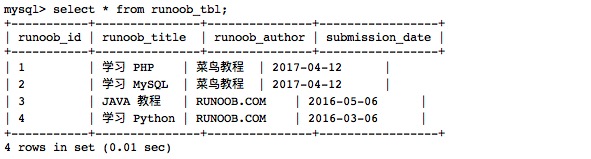
runoob_tbl Data of:Example 
runoob_tbl All records of:select\*fromrunoob_tbl;