最近几年来,地理信息系统无论是在理论上还是应用上都处在一个飞速发展的阶段。 GIS被应用于多个领域的建模和决策支持,如城市管理、区划、环境整治等等,地理信息成为信息时代重要的组成部分之一; “数字地球”概念的提出,更进一步推动了作为其技术支撑的GIS的发展。 与此同时,一些学者致力于相关的理论研究,如空间感知、空间数据误差、空间关系的形式化等等。 这恰好说明了地理信息系统作为应用技术和学科的两个方面,并且这两个方面构成了相互促进的发展过程。
9.39.1. Brief introduction 
GameKit is a commonly used framework in iOS SDK. It has three core functions:
Interactive game platform Game Center
P2P device communication function
In-Game Voice .
9.39.2. Instance step 
1.在链接 iTunes 时请确保拥有一个唯一的 App ID( unique App ID),App ID在我们应用程序更新 bundle ID时及在Xcode代码签名与相应的配置文件需要使用到。
2.创建新的应用程序和更新应用程序信息。在添加新的应用程序文档可以了解更多有关信息。
3.打开你申请的application,点击Manage Game Center选项。进入后点击Enable Game Center使你的Game Center生效。接下来设置自己的Leaderboard和Achievements。
4.下一步涉及处理代码,并为我们的应用程序创建用户界面。
5.创建一个single view application,并输入 bundle identifier 。
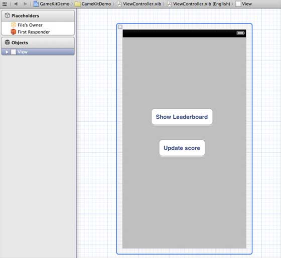
6.更新 ViewController.xib,如下所示
7.选择项目文件,然后选择目标,然后添加GameKit.framework
8.为已添加的按钮创建IBActions
9.更新ViewController.h文件,如下所示
#import #import @interface ViewController : UIViewController <GKLeaderboardViewControllerDelegate> -(IBAction)updateScore:(id)sender; -(IBAction)showLeaderBoard:(id)sender; @end 10.更新ViewController.m ,如下所示
#import "ViewController.h" @interface ViewController () @end @implementation ViewController - (void)viewDidLoad { [super viewDidLoad]; if([GKLocalPlayer localPlayer].authenticated == NO) { [[GKLocalPlayer localPlayer] authenticateWithCompletionHandler:^(NSError *error) { NSLog(@"Error%@",error); }]; } } - (void)didReceiveMemoryWarning { [super didReceiveMemoryWarning]; // Dispose of any resources that can be recreated. } - (void) updateScore: (int64_t) score forLeaderboardID: (NSString*) category { GKScore *scoreObj = [[GKScore alloc] initWithCategory:category]; scoreObj.value = score; scoreObj.context = 0; [scoreObj reportScoreWithCompletionHandler:^(NSError *error) { // Completion code can be added here UIAlertView *alert = [[UIAlertView alloc] initWithTitle:nil message:@"Score Updated Succesfully" delegate:self cancelButtonTitle:@"Ok" otherButtonTitles: nil]; [alert show]; }]; } -(IBAction)updateScore:(id)sender{ [self updateScore:200 forLeaderboardID:@"runoob"]; } -(IBAction)showLeaderBoard:(id)sender{ GKLeaderboardViewController *leaderboardViewController = [[GKLeaderboardViewController alloc] init]; leaderboardViewController.leaderboardDelegate = self; [self presentModalViewController: leaderboardViewController animated:YES]; } #pragma mark - Gamekit delegates - (void)leaderboardViewControllerDidFinish: (GKLeaderboardViewController *)viewController{ [self dismissModalViewControllerAnimated:YES]; } @end
9.39.3. Output 
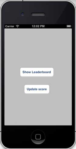
Run the application, and the output is as follows
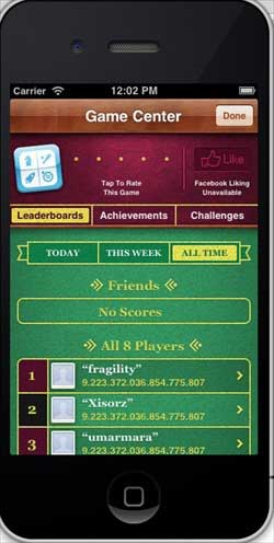
When we click to display the rankings, the screen displays as follows:
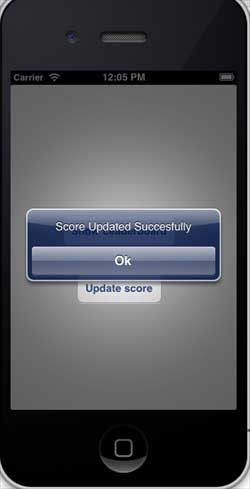
When we click to update the score, the score will be updated to our ranking, and we will get a message, as shown in the following figure
-
1. Angularjs2
8
-
1. SVG tutorial
19
-
1. Memcached
20
-
1. C# tutorial
61
-
1. Sqlite
47
-
2. Go
43
-
2. Docker
59
-
2. Vue3
19
-
2. Servlet
21
-
3. React
23
-
3. SOAP tutorial
10
-
3. Android
18
-
3. Mongodb
44
-
3. Kotlin
18
-
4. Lua
31
-
4. MySQL tutorial
35
-
4. Appml
12
-
5. Perl
45
-
5. Postgresql
41
-
web
15
-
5. Web Services tutorial
6
-
6. Ruby
42
-
6. Design-pattern
35
-
7. Django
18
-
7. Rust
22
-
6. WSDL tutorial
8
-
8. Foundation
39
-
9. Ios
43
-
9.22. The use of IOS View switching
-
9.5. Create the first iPhone application
-
9.19. Use of table view
-
9.33. IOS sends email
-
9.31. IOS positioning operation
-
9.28. IOS accelerometer (accelerometer)
-
9.7. Delegate (Delegates) example
-
9.37. In-app purchase of IOS
-
9.40. IOS storyboard (Storyboards)
-
9.10. Why use different input types?
-
8. Css3
26
-
9. Swift
44
-
11. HTML tutorial-(HTML5 Standard)
54
-
12. Http
6
-
13. Regex
6
-
14. Regexp
8
-
1. Introduction to geographic information system
6
-
2. From the Real World to the Bit World
3
-
3. Spatial Data Model
7
-
4. 空间参照系统和 地图投影
5
-
5. Data in GIS
3
-
6. Spatial data acquisition
2
-
7. Spatial Data Management
6
-
8. Spatial analysis
8
-
9. 数字地形模型( DTM )与地形分析
5
-
10. 空间建模与 空间决策支持
6
-
11. Spatial data representation and map making
6
-
12. 3S Integration Technology
5
-
13. 网络地理信息系统
3
-
14. Examples of Geographic Information System Application
8
-
15. Organization and Management of Geographic Information System Application Projects
9
-
16. Geographic Information system Software Engineering Technology
6
-
17. Geographic Information System Standards
3
-
18. Geographic Information System and Society
3
-
19. Earth Information Science and Digital Earth
3