最近几年来,地理信息系统无论是在理论上还是应用上都处在一个飞速发展的阶段。 GIS被应用于多个领域的建模和决策支持,如城市管理、区划、环境整治等等,地理信息成为信息时代重要的组成部分之一; “数字地球”概念的提出,更进一步推动了作为其技术支撑的GIS的发展。 与此同时,一些学者致力于相关的理论研究,如空间感知、空间数据误差、空间关系的形式化等等。 这恰好说明了地理信息系统作为应用技术和学科的两个方面,并且这两个方面构成了相互促进的发展过程。
11.14.1. HTML table instance 
First Name | Last Name | Points |
|---|---|---|
Jill | Smith | 50 |
Eve | Jackson | 94 |
John | Doe | 80 |
Adam | Johnson | 67 |
11.14.2. HTML form 
The form is composed of It appears in the browser as follows: If you do not define border properties, the table does not display borders. Sometimes this is useful, but most of the time, we want to display the border. Use the border properties to display a table with borders: Use of the header of the table Most browsers display the header as text centered in bold: It appears in the browser as follows: Label Description < table > Define form < th > Define the header of the table < tr > Define the rows of the table < td > Define table cells < caption > Define the table title < colgroup > Define the group of table columns < col > Define properties for table columns < thead > Define the header of the table < tbody > Define the body of the table < tfoot > Define the footer of the table tag to define. Each table has several rows (made up of
tag definition), each row is divided into severalcells (by label definition). The letter td refers to tabular data(table data), that is, the contents of data cells. Data cells can contain text, pictures, lists, paragraphs, forms, horizontal lines, tables, and so on. 11.14.3. Table example 
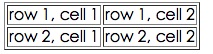
Example 
<tableborder="1"><tr><td>row 1, cell 1td><td>row 1, cell 2td>tr><tr><td>row 2, cell 1td><td>row 2, cell 2td>tr>table>
11.14.4. HTML Table and Border Properties 
Example 
<tableborder="1"><tr><td>Row 1, cell 1td><td>Row 1, cell 2td>tr>table>
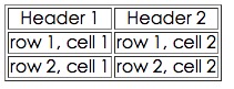
11.14.5. HTML table header 
tag is defined. Example 
<tableborder="1"><tr><th>Header 1th><th>Header 2th>tr><tr><td>row 1, cell 1td><td>row 1, cell 2td>tr><tr><td>row 2, cell 1td><td>row 2, cell 2td>tr>table>
11.14.6. HTML form label 