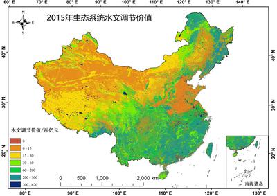
Spatial Distribution of China's Terrestrial Ecosystem Service Value - Hydrological Regulation Data
发布时间 :2026-01-22 00:58:32 UTC
类别 : Ecology
Different land use types exhibit distinct ecological service functions and values. The 'China's Terrestrial Ecosystem Service Value Spatial Distribution Dataset' is based on national-scale remote sensing classification of terrestrial ecosystem types, encompassing 15 secondary categories: dryland, farmland, coniferous forest, mixed coniferous-broadleaved forest, broadleaved forest, shrubland, grassland, shrub-grassland, meadow, wetland, desert, bare land, water systems, glaciers/snow cover, and artificial surfaces (including construction land and industrial-mining land). These secondary categories are grouped under six primary land use classes: farmland, forest, grassland, wetland, desert, and water bodies.