Spatial Distribution of China's Terrestrial Ecosystem Service Value - Biodiversity Data
发布时间 :2026-01-22 00:58:36 UTC
类别 : Ecology
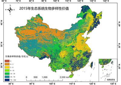
Different land use types possess distinct ecological service functions and values. The 'China's Terrestrial Ecosystem Service Value Spatial Distribution Dataset' is grounded in nationwide remote sensing classification of terrestrial ecosystem types, encompassing 15 secondary categories: dryland, farmland, coniferous forest, mixed coniferous-broadleaved forest, broadleaved forest, shrubland, grassland, shrub-grassland, meadow, wetland, desert, bare land, water systems, glaciers/snow cover, and artificial surfaces (including construction land and industrial-mining land). These secondary categories are systematically grouped under six primary land use classes: farmland, forest, grassland, wetland, desert, and water bodies.